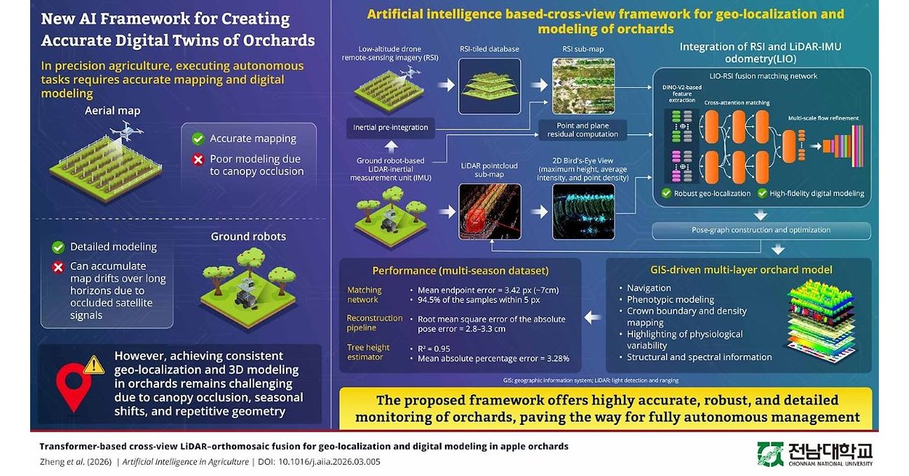
A research team at Chonnam National University has developed an artificial intelligence framework capable of creating highly accurate digital models of commercial orchards by combining aerial drone imagery with ground-based LiDAR data, an advance that could significantly improve the performance of autonomous agricultural robots and precision farming systems.
The study, led by Professor Kyeong-Hwan Lee from the university's Department of Convergence Biosystems Engineering, addresses one of the most persistent challenges in orchard automation: generating reliable maps and three-dimensional models in dense, tree-covered environments where conventional navigation technologies often struggle. The research was published in the June 2026 issue of Artificial Intelligence in Agriculture.
Modern orchards are becoming increasingly dependent on automation as growers grapple with labour shortages, rising production costs and the need to improve productivity through data-driven farming. Yet dense tree canopies often interfere with satellite signals, making it difficult for autonomous ground vehicles to maintain accurate positioning over large orchards. While drones can generate detailed aerial maps, they typically fail to capture the complex structure beneath tree canopies. Ground-based LiDAR systems, meanwhile, excel at recording tree architecture but accumulate navigation errors over long distances.
Rather than relying on a single source of information, the Chonnam research team developed a cross-modal AI framework that enables drones and autonomous ground robots to "see" the same orchard from different perspectives and merge those observations into a unified digital representation.
The system processes low-altitude drone imagery into detailed orthomosaic maps while simultaneously converting LiDAR data collected by ground robots into structured bird's-eye-view maps that preserve essential three-dimensional information. A transformer-based deep learning model then aligns the two datasets by recognising common orchard features—including tree rows, canopy structures and open spaces—despite differences in viewing angles, seasonal conditions and repetitive orchard layouts.
By integrating these complementary data streams into a geographic information system (GIS)-based pose graph, the researchers created multilayer digital orchard models capable of supporting autonomous navigation while also enabling detailed analysis of tree structure, crop phenotypes and plant health.
Field evaluations demonstrated localisation accuracy within just a few centimetres while significantly reducing the long-distance positional drift that commonly affects ground-based robotic systems operating beneath dense foliage. The framework also remained reliable under changing seasonal conditions and was designed to operate efficiently on embedded computing platforms, making real-time deployment in commercial orchards increasingly practical.
Beyond improving robotic navigation, researchers believe the technology could become a foundation for continuously updated "living digital twins" of orchards, allowing growers to monitor crop performance, detect structural changes, optimise field operations and make more informed management decisions throughout the growing season.
The development reflects a broader shift across global agriculture, where artificial intelligence, robotics and geospatial technologies are increasingly converging to improve productivity while reducing dependence on manual labour. As commercial orchards continue to embrace automation, accurate digital models are expected to become critical infrastructure for robotic harvesting, precision spraying, autonomous scouting and predictive crop management.
Professor Lee said the long-term vision extends beyond navigation, with future digital orchard models serving as intelligent decision-support systems capable of helping farmers respond more effectively to seasonal changes, environmental stress and evolving production challenges.
The research, titled "Transformer-based Cross-view LiDAR–Orthomosaic Fusion for Geo-localization and Digital Modeling in Apple Orchards," was published in Volume 16, Issue 2 of Artificial Intelligence in Agriculture after first appearing online in March 2026.